
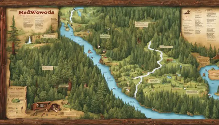
Nothing compares to the ethereal beauty of the Redwoods National Park, one of nature’s most spectacular spectacles. A comprehensive understanding of the park’s map is key to exploring and fully appreciating all that this wonderland has to offer. This discussion aims to provide an in-depth comprehension of the Redwoods National Park map, interpreting various mapping symbols ranging from landmarks to camping sites and unfolding the intricacies of trail conditions and their depicted difficulty levels on the map. The ultimate goal is to empower you, as a prospective visitor, with the ability to leverage the map for optimizing your exploration plan, covering points from estimating travel times to identifying attractions.
Understanding the Mapping Symbols
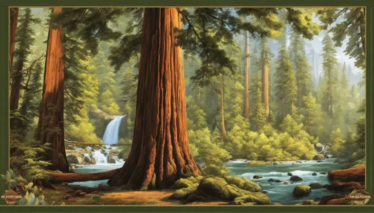
Enchanting forests, mystical fog, and towering redwoods that kiss the sky – there’s something magically captivating about the serene wilderness of Redwoods National Park. This captivating wonderland offers more than just picturesque landscapes; it’s a maze that’s teeming with raw, untouched beauty, just waiting to be explored. And what’s a labyrinth without a proper map to guide those willing to undertake the adventure? Today, we’re focusing on deciphering the enigmatic symbols found on your Redwoods National Park map.
Starting off, there are some familiar symbols on this map that you’ll see on pretty much any map. Highways, for example, are indicated by numbered, thick red lines – the lifelines connecting different sections of the park. Smaller, colored lines represent minor roads, where the code to cracking the color scheme lies in the map’s legend – typically blue for county roads, black for park roads, and gray for unpaved roads.
Keep an eye out for the green patches, representing the main draws of this beautiful reserve – vegetative beauty and hiking trails where under the towering redwoods you’ll feel infinitesimally small yet strangely connected to the vastness of the universe. Those dotted lines, carving a path through the green, represent hiking trails – each step taking you deeper into the heart of the wilderness.
Don’t be alarmed by a symbol that looks like a tent, it’s an indication of a campground. These emblematic tent symbols instigate fleeting imagery of roasting marshmallows on open fires under the twinkling stars. Get ready, camper enthusiasts! Redwoods National Park offers a myriad of camping sites, each providing unique experiences.
The quite literal fish-out-of-water symbol on the map signifies fishing spots where the fishing enthusiasts can reel in a new story. Similarly, picnic tables represent picnic areas because, let’s be real, who wouldn’t enjoy a meal amidst such natural grandeur?
Feeling more adventurous? Kayaking areas are also part of this magical journey and are symbolized by a tiny stick figure rowing a kayak. With helmets, life jackets, and courage on, conquering the rippling waves is sure to transform you from a mere traveler to an adventurer.
The Redwoods National Park map also includes symbols like the, restroom, gift shop, and visitor centers, represented by tiny buildings, essentially mini lifelines for all traveler-related queries and necessities.
That said, this guide only just peels back the layer on the denotations behind the symbols on the Redwoods National Park map. Each symbol is a cryptic guide, leading the way to your next exciting experience. So pack your essentials, lay your hands on this map, and let the harmony of nature guide you through the spiritual journey that awaits in the Redwoods National Park. Happy wandering, friends!
Identifying Trail Conditions and Difficulty Levels
Unveiling Adventure: Decoding the Redwoods National Park Map
Ever been overwhelmed by adventure wanderlust? If so, welcome to the international tribe of trailblazers! Today, let’s take a virtual trip to the lush, verdant world of Redwoods National Park. It’s time to decode that park map and discover all the natural wonders awaiting us.
On our itinerary is the abridged guide to the trail conditions and difficulty levels. Sure, we’ve already traversed the highways, roads, hiking trails, campgrounds, fishing spots and so much more. Now, it’s time to explore the less chartered terrains.
What looks like a simple sheet of paper is actually a treasure map to your next unforgettable adventure. When you master the Redwoods National Park map, nothing can stand in the way of an extraordinary journey embedded amid the majestic redwood trees.
Every trail has a tale to tell and an experience to offer. The key to cracking this enigma is understanding the trail symbols and notations. With multiple trail options to choose from, the park map employs a series of symbols to indicate the nature of the trail. You’ll find marked trails ranging from “Easy” to “Difficult”, providing an indication of what lies ahead. Cross-reference these markers against your physical capabilities and strengths to ensure a safe and enjoyable hiking experience.
Besides, do pay heed to any colored coded strips or dashes. Usually, these represent a change in the condition of the trail. Variations include rocky terrains, steep slopes, muddy paths, or narrow trails. Remember, challenging terrain could make a trail more strenuous.
Even the trail lengths are marked, enabling you to plan your hiking journey better. Keep in mind, longer trails could turn an “Easy” route into a “Moderate” or even “Difficult” one providing a challenge even for the very fit. The trail lengths make it easier to map out your day and ensure you have ample time for all your escapades.
For those with an adventurous streak and a genuine love for the wilderness, don’t miss the trails marked as “Unmaintained”. While less safer owing to their minimal supervision, these trails offer hikers the raw, undiluted taste of Mother Nature’s astonishing beauty and uncharted paths.
A couple of wrinkles to watch out are the forest road and river crossing symbols. They are key indicators of potential obstacles in the trail that might affect the level of difficulty. Forest roads could mean vehicular traffic, while river crossings denote trails that may lead through high water areas in certain seasons.
Remember, it’s not just about treading the path, but about truly living the journey, one stride at a time. Keep your eyes open, remain flexible, deepen that connection with Nature, and remember the golden rule of any adventurer, “The map is not the territory”. It’s time for your boots to kiss the ground and your spirit to fly. Journey on, intrepid travelers. A world of wonder awaits in Redwoods National Park. Bon Voyage!

Using the Map to Plan Your Visit
Exploring the untamed wilderness of the Redwoods National Park might seem a daunting prospect, but the guidance provided by its map is the key to unlocking the beauty and adventure of this enigmatic location.
Let’s delve into the seasonal areas. Ah, the magic of the changing seasons! Its impact might be missed by the common wanderer, but a digital nomad knows better. See those sections on your map marked with dots of different colors – yellow, orange, and red? These depict areas that are accessible only during certain parts of the year. Yellow indicates spring, with orange for summer, and so on. Plan ahead and harmonize your visit with the rhythm of mother nature.
Scope the diverse wildlife viewing opportunities available. The symbols dotted over the map, be it the fluttering bird, the bounding deer, or the leaping fish, indicate the prime spots for wildlife observation. For those eager to encounter several creatures in the wild, these markers will enhance the vibrancy of the travel experience.
Notice also the bicycle logo emblem? This represents established biking routes, whether you’re in for an effortless glide on cycling-dedicated flat paths or adrenaline-filled off-road jaunts. With the map in hand, pedaling through the Redwoods becomes a more navigable prospect.
But let’s not forget backcountry campsites. When searching for solitude, move away from the hustle of the world and into the serenity of the wild. Look for the tent symbols scattered just a bit off the regular trails. These jewels in the wilderness are just waiting to greet adventurous souls with the gentle call of the wild.
Now, one mustn’t forget safety either! Remember those dashed lines on the map, circling an area with a flame symbol in the center? That’s the map’s way of guiding you about designated fire-prone zones in different seasons. Heed this warning and avoid setting up campfires in these regions.
Let’s move to the roads less traveled – literally! A quick glance at the map shows you multiple roads slightly faded or not prominently highlighted. These signify scenic byways, roads less frequented, typically devoid of bustling traffic. They hold the potential for breath-taking views and an intimate experience with the wilderness.
It’s also handy to note areas around the park that would facilitate better cell reception, also marked on the map. While the world right within the park is a delightful bubble of natural wonder, constantly being connected becomes a boon when coordinating with fellow travelers or in case of emergencies.
So, when preparing for the Redwoods National Park trip, do remember this – the map isn’t just a piece of paper, it’s a storytelling canvas. It teaches, intimates, and guides, urging you to look beyond the obvious, wander fearlessly and relish extraordinary experiences along your journey.
So, fellow adventurers, gear up! Harness the wisdom of the map, proffered ever so artfully, and let your spirits soar amidst the beautiful Redwoods. Godspeed!

By harnessing the knowledge provided herein, prospective visitors will be equipped with the integral skills necessary for map-based route planning, enhancing their overall park visit experience. Demystifying the symbols, recognizing trail conditions and difficulty levels, and understanding how to plan the visit strategically using the map allows for a more immersive, seamless, and enriching Redwoods National Park journey. May your sense of adventure be heightened by the confidence that comes from understanding how to navigate and traverse the pathways and landmarks of this iconic natural preserve effectively.
Proud owner of https://travelyouman.com/
